I’ve hiked trails in New York’s Adirondack and Catskill Mountains, in the Wharton and Lebanon State Forests in my native New Jersey, and even sections of the famed Maine to Georgia Appalachian Trail. So, imagine my surprise when I listened to Jordi St. John, business engagement manager for the Maine Island Trail Association (MITA), describe the Maine Island Trail.
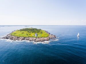
St. John’s answer reminded me of a scene from the movie, The Wizard of Oz. He first said there is no set route. You can go north or south or some people go both ways, just like the Scarecrow directed Dorothy in her search for the Emerald City. Then, it got even better. St. John added that there is no starting point or ending point. Some 246 sites make up this 375-mile water-based recreational “trail” of islands that spans the length of the state’s coast from the New Hampshire border north to the Canadian line.
“You can visit one, or visit them all,” says St. John, who spent summers as a kid cruising with his parents on the family’s Hood 38 sailboat and today does the same in a 22-foot Grady White with his wife and eight- and 10-year-old children. “You can go out for just an afternoon, or a day, or several days and camp on your boat or one of the islands. You can visit on a megayacht, or cruise on a 40- to 50-foot sailer, powerboat, or explore in a small powerboat, or by paddle in a kayak or paddleboard. There is no right way or wrong way, only what you enjoy,” he says.
The whim of the weather is another reason for no hard and fast routes. Ten-foot tides, tidal currents, wind and dense fog can make some parts of the trail less accessible at times. So, planning is imperative.
The Trail
What would formally become the Maine Island Trail started several thousand years ago when miles-deep mega-glaciers depressed areas of land along what is now the state’s coast. As these frozen behe-moths melted, portions of land popped back up while others laid low and filled with water.
Along the way, craggy rock cliffs, pebbly coastlines and sandy beaches formed. Today, more than 3,000 islands are located along Maine’s 3,500-mile coastline. While nowadays many are uninhabited, through history they’ve served as grazing grounds for sheep, granite quarries, homesteads for fishermen and shipbuilders, perches for lighthouses, and some even have leftover military structures from World War II.

The launch of a land survey in the 1970s revealed the State of Maine held title to over a thousand of these islands. A decade later, the state collaborated with the nonprofit Island Institute with an eye toward these properties’ recreational potential. This springboard, along with a grassroots effort by residents to visit and protect these islands, led to the MITA’s founding in 1988.
At first, the trail included 30 to 40 islands owned by either state or federal entities. Over the years, the trail grew through a series of unique handshake agreements with private landholders that allow public visitation. This handshake comes with the MITA’s stewardship, which includes monitoring and trash removal to maintain a pristine, leave-no-trace character. The trail is now roughly made up of one-third privately owned islands, one-third state-owned and one-third federal lands. All are accessible. The MITA’s trail guide app offers a wealth of detailed information for trip planning. The organization also offers educational talks and events throughout the year.
“The interface of land and sea is a big part of the enjoyment of boating,” says Bob Arrington, a marine journalist who has cruised much of the trail with his wife on their 54-foot trawler, often anchoring overnight as well as exploring nooks and crannies of coves and coastline by kayak. “The ability to explore, to visit these islands and know that you’re not trespassing is a huge draw.”
Indeed, in 2018, National Geographic named the Maine Island Trail as one of the 50 Best American Adventures.
Day Tripping
A good way for the trail’s first timers to get their feet wet is on a day trip. The Portland area is a good launching place as it’s easy to reach and has facilities such as marinas, lodgings, restaurants and more as a home base. Portland sits to the south of Casco Bay, an inlet in the Gulf of Maine.
“Casco Bay is busy because of its proximity to Portland, plus it has over 60 islands within easy public access. Several islands are part of MITA here,” says Maria Jenness, MITA’s regional stewardship manager, who is a Master Maine Sea Kayak guide and travels among the islands in an 18-foot skiff.
One of these islands, Little Chebeague, is a mix of gravel and sand beaches that makes this 86-acre island ideal for a picnic trip. Trails with interpretive signs talk about the late 19th-century summer resort that once thrived here. Remnants of World War II are here too, evidenced by a steel building on the southeast beach once used for Naval shipboard firefighter training.
To the northeast, passing Great Chebeague along the way, is 55-acre Bangs Island. The island’s north end boasts a couple of picnic-perfect beaches, as well as picturesque views of northern Casco Bay. In 2020, the Freedom Boat Club (FBC) of Maine partnered with MITA to provide free membership to its members and in turn adopted Bangs Island to make sure its public areas were clean and well-maintained.
“This came at a time when visitation to the island skyrocketed as people sought safety and solitude from the pandemic,” says Tracy Coughlin, FBC’s marketing director. Club membership offers use of a fleet of 22- to 25-foot inflatables and center consoles, which makes a nice way to explore the MITA for someone who doesn’t have or can’t BYOB (bring your own boat).
Camp Out
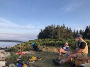
Overnight or multi-night camping is a big draw on many MITA islands. In the Casco Bay area, this includes 221-acre Jewell, located about 3 miles southeast of Little Chebeague and 15 miles offshore from Portland. Visitors find 12 campsites and primitive privies, and fires are allowed in designated fire rings. Raccoons make it imperative to lock up food. Those who want to camp overnight on their boats can drop anchor in Cocktail Cove on the island’s northwest side.
“Jewell has several campsites and is most likely the busiest on the weekends. There are several campsites in the cove or punch bowl, which is a huge tidal pool with lots of marine life, including lobsters. My favorite is the campsite located in the middle of the island on the west shore. A private area with a spectacular sunset view and sand beach,” says Chris Saxton, manager and second-generation family owner of the 60-slip Dolphin Marina & Restaurant, located in Harpswell, ME, on Casco Bay.
Off the Beaten Trail
The trail also offers great opportunities for day and overnight camping trips farther north. Seventy-acre Warren Island State Park, about 9 miles northeast of Camden in Penobscot Bay, has a dock and beach on the east side of the island, as well as a small campground.

Even more off the beaten track near Jonesport, Molly Cove on the 71-acre Great Wass Island Preserve is day-use only with a beautiful, sheltered cove rimmed with a beach ideal for picnicking. There’s also a four-mile hiking trail with rare flora along the way from the beachhead iris to huge stands of coastal jack pine and bogs where the rare edible baked-apple berry grows.
Overnighters can go farther down east less than a mile across the Mud Hole Channel to the one-acre Little Water Island. There’s enough camping room for two among the spruce trees on this grassy rock of an island. It’s a location surreal enough to think you’re in Oz. But this isn’t Kansas, it’s Maine, with a jewel of an island-lined coast at its best. For more info, go to mita.org


