Jagged shorelines and peninsulas shaped like crooked fingers make the Chesapeake a gorgeous place to explore. Some people are content to gaze at the scenery and enjoy what Mother Nature gave us. Others choose to alter the master plan.
Tinkering with the Bay’s land and waterways started centuries ago, driven by the need to transport goods and people. Over time the population grew, agriculture flourished and manufacturing boomed, but old-fashioned ferries, steamboats and rickety wooden bridges couldn’t keep up with growing demands.
Engineers sharpened their pencils and drew plans to build structures that would make the region more hospitable to modern living. Their ideas were bold and ingenious but often questioned by skeptics. And Mother Nature didn’t accept change without a fight. She reached into her bag of tricks and bombarded workers with choppy seas, harsh winter winds, hurricanes and the infamous Chesapeake nor’easters.
Despite all odds, mankind accomplished incredible engineering feats from the Susquehanna headwaters to the southern Atlantic shores. Three exceptional structures changed the way people travel around the Bay — the Bay Bridge, Chesapeake & Delaware Canal and the Chesapeake Bay Bridge & Tunnel. Here’s how these landmarks came to be and why they’re worth a visit.
The Bay Bridge
Why would anyone dare to build a tall suspension bridge across an expanse of water known for high winds and unpredictable squalls? Since colonial times, Maryland has been divided by a big belly full of water. The western side of the Bay hummed with commerce, government and busy ports. The rural eastern part flourished with plush farmlands, fishing villages and vacation spots. It almost felt like two different states.
When the urban trinity of Baltimore, Annapolis and Washington swelled with growth, people needed to stretch beyond their western corridor. Plus, Eastern Shore farmers wanted to bring their wares with ease to city markets, and beach towns were luring visitors to their seaside attractions.
Plans to span the Chesapeake’s midsection started in the late 1800s, but the idea got shelved during the Great Depression and World War II. In 1947, Maryland Gov. William Preston Lane Jr. spearheaded an effort to bridge the “narrow” 4.3-mile distance between Sandy Point and Kent Island.
By 1949, construction workers began dropping massive concrete piers into the waves. Within a year, crews completed what looked like giant stepping stones in the water, along with a pair of 354-foot-tall towers that would harness suspension cables. In 1952, the first car drove across the 22,970-foot span, which was heralded as the longest continuous over-water steel structure and the third longest bridge in the world.
The entire East Coast marveled at this architectural wonder. Unfortunately a new problem ensued. In the first year, 1.2 million vehicles raced across the two-lane bridge. Within 10 years, traffic skyrocketed and strained the span’s capacity. Engineers went back to the drawing board and designed a parallel structure completed in 1973.
Seasonal traffic remains an issue, but if you cross the Bay Bridge during off-peak hours, you’re in for a spectacular show. Sunsets are breathtaking. The sky-high view among the clouds and seagulls makes gigantic cargo liners on the water look like tiny bathtub toys.
Chesapeake Bay Bridge Tunnel
With the Bay’s top and midsection flowing smoothly, Virginia eyed the benefits of modern rapid transit and began to assess its piece of the Chesapeake’s southern waters. On top of the list was the link between Virginia’s Eastern Shore and the Norfolk/Virginia Beach area. Ferryboats ran regularly between those points, but boosting the service didn’t match the popular local resorts’ rise in traffic.
Initial plans to span the channel were met with resistance by critics who believed the space was too wide and bridges couldn’t accommodate Navy warships and cargo vessels.
The solution was so ambitious that many were convinced it was destined to fail. In 1960, construction began on a project that would be named one of the Seven Engineering Wonders of the Modern World. Nearly 2,000 workers toiled on the Bay Bridge Tunnel.
In 1964 — just 42 months after the launch date – the end result was the world’s largest bridge-tunnel complex that crossed over and under 17.6 miles of open waters. It entails more than 12 miles of low-level trestle, two mile-long underwater tunnels, two high-span bridges, almost two miles of causeway and four man-made islands. As if that wasn’t enough, a second parallel span was completed in 1999.
Chesapeake Bay Bridge Tunnel is an adventure that every Bay explorer should take. It’s a magnificent testament to mankind’s ingenuity and determination to tame nature’s aquatic challenges. With waves splashing just beyond your windows, the view is beyond compare of vessels ranging from sailboats to aircraft carriers. An added bonus: One island has a restaurant, gift shop and fishing pier where visitors can take time to experience this engineering wonder.
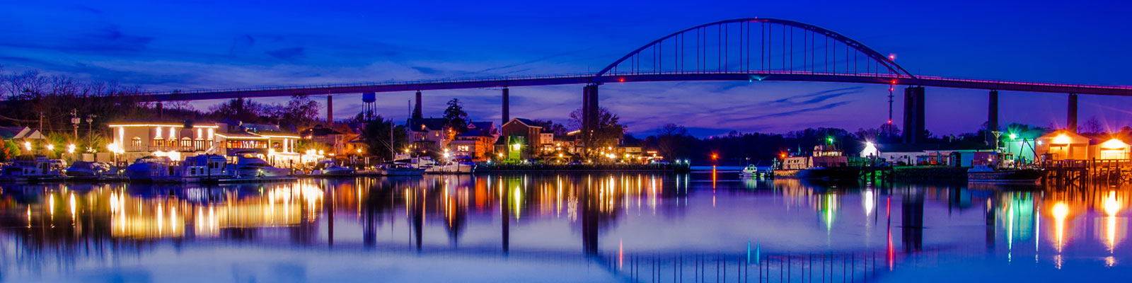
Chesapeake & Delaware Canal
Augustine Herman, a 17th-century Dutch mapmaker, was the first to note the thin strip of land separating the Chesapeake Bay’s northern tip from the Delaware River. In 1788, Ben Franklin and his cronies also toyed with the project, but it got lost in the shuffle of launching a new nation.
Businessmen in Philadelphia and Baltimore saw the economic value of reducing the journey between their ports, so they lobbied Maryland, Delaware and Pennsylvania legislatures to turn the 14-mile stretch of land into a waterway. Their efforts paid off, and in 1802 the Chesapeake & Delaware Canal Co. was formed. They conducted surveys, drew plans and began digging in 1804. Lack of funds caused several false starts, but by 1824 construction resumed in earnest. It wasn’t easy going. Workers labored with pickaxes, shovels and rudimentary dredging machines through soggy marshlands and dense forests. Heavy winter rains turned solid ground into knee-deep mud pits. But with persistence, resourcefulness and tons of rocks and wood, the canal opened in 1829.
Only 10 feet deep and 66 feet wide, the channel used mules to tow ships through four locks that lifted water to higher levels with steam-operated waterwheels. By the early 1900s, the canal struggled to accommodate large vessels and heavy traffic, so the U.S. government bought it in 1919 and poured $2.5 million into expansions. Engineers removed the locks, dredged the channel down to sea level for smoother sailing, and built bridges overhead.
For decades, the Army Corp of Engineers widened and fortified the C&D Canal to keep pace with transportation needs. Today, the structure is 450 feet wide and 35 feet deep and brings 40 percent of all ship traffic into Baltimore.
Cruising through the busy canal is an unforgettable experience, because you share the journey with massive cruise ships, cargo vessels and tugboats pulling overloaded barges. Quaint towns and bustling dock bars line the shores. To get the full scoop on this amazing waterway, visit the C&D Canal Museum in Chesapeake City, MD.